By Yuan Quan, People’s Daily
On Dec. 8, 2020, China and Nepal jointly announced that the newheight of Mount Qomolangma, the world’s highest peak,is8,848.86 meters.The figure was imprinted on the mind of Li Guopeng, chief commander of the measurement task.
Measuring the height of Mount Qomolangmamirrors human beings’ ambition to transcend themselvesand represents a country’soverallnational strengthas well asscientific and technological capabilities, said Li, who is also captain of the First Geodetic Surveying Brigade under China’s Ministry of Natural Resources (MNR).
Due to its complex environment and unpredictable weather, Mount Qomolangmais only suitable for climbing in May.
On May 27, 1975, a Chinese team placed a surveyor’s beacon on the summit of Mount Qomolangma for the first time, and accurately measured its height, which was 8,848.13 meters.
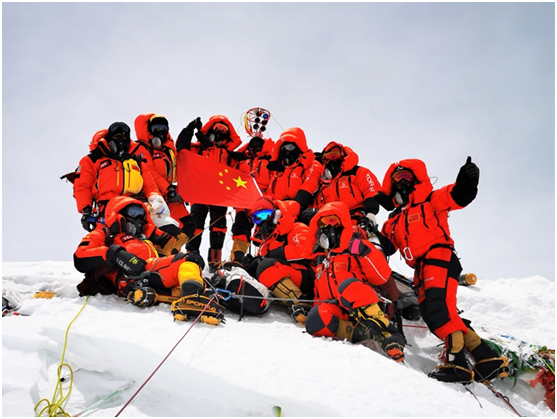
Forty-five years later, a new generation of Chinese surveyors reached the summit of Mount Qomolangmaon the same day in 2020, and erected a red surveyor’s beacon on the world’s highest peak again.
On the peak of the mountain, surveyors needed to set up beacons as quickly as possible and adjust their angles so that the laser ranging signals reflected from the prisms on the beaconscan be received at six intersection points at the mountain’s base, according to Li.
Meanwhile,the survey team also conductedGlobal Navigation Satellite System (GNSS),high-precision gravity, andmeteorological surveys, andused radar to measure the depth of snow while at the summit of the mountain, Li said.
When Chinese surveyors measured the height of Mount Qomolangma in 2005, their equipment was imported from abroad, including GNSS and snow depth radar, according to Li.
“Fifteen years later, wefinally completed the measurement task successfullywith domestic equipment,”Li noted.
On the evening of May 28, 2020, members of the Chinese survey teamreturned safely to their base camp following the completion of relevant surveyson Mount Qomolangma.
After technicians confirmed that all the data had been well collected and stored, Li was finally relieved.
The 2020 measurement task marked multiple “firsts” in China’s surveying history, including the first time that the BeiDou Navigation Satellite System (BDS), which is independently developed by China, was used to measure the geodetic height of Mount Qomolangma, the first time humankind measured the gravity value of the mountain’s peak, and the first time a global vertical datum was established for Mount Qomolangma.
Gravity data is of great value for the study of changes to the earth’s crust and glaciers.
“Back in 2005, we were only able to conduct gravity survey for the mountain with imported gravimeters at analtitude of no more than 7,790 meters, while domestic gravimeters can now perform normally even at the peak of the mountain,” said Li.
The gravimeter needed to be kept vertical on flat ground, which was not an easy thing to do in the harsh environment of Mount Qomolangma, he noted.
To ensure the stability of the gravimeter, surveyors stayed up all night in the tent to guard the device at an altitude of 8,300 meters, Li disclosed.
According to Li, surveyors improved their equipment creatively to ensure the accuracy and reliability of datacollected in the low-temperature, low-pressure, low-oxygen environment of Mount Qomolangma.
Pointing to the snow depth radar, Li explained that there is a USB interface under the rubber sleeve of the device. The USB interface can support real-time data transmission and external memory card, thus helping ensure data safety in emergencies, Li said.
The reliable data collected in thesuccessful measurementtask indicate that a batch of home-made equipment, including the BDS and GNSS receivers, has stood the test of extremely high altitude and cold environment on MountQomolangma,and demonstrated the high quality and great accuracy of Chinese equipment, Li pointed out.